| Editor's choice |
Holyear vs. Teethson
An animated boxing fight between a human ear and a wind-up chattering teeth.
Image copier
A free and useful image tool for programmers, artists and normal users...
Free Sportsmen Screensaver
Sport is an integral part of our life.
GoalAchiever
A stupid $20 tool, which will increase chances of achieving your goals by 1100%
Timer Clock
Timer Clock notices you about coming time. Timer Clock useful Desktop Tool.
American Flag With Eagle
Watch as an artist's hand draws an eagle on the American flag.
Blue Mosque 3D
A picturesque and vivid dream of many orient sultans and tsars!
|
|
Innovative software application solutions from the greatest in download catalogs! Surf the called for applications sections, determine the freshest updates of the notable solutions, and acquire immediately! Do not lose an advantage to download the best applications: use SoftEmpire to download programs for free. Meet the aggregation of free programs and computer software versions. pick out among system applications, test controllers, antiviruses, and all other types of utilities for your PC or cellular gadgets!
Shareware, freeware collection of exceptional desktop themes, screensavers, 3d wallpapers, icons and ICQ skins are available to download.
|
Canvas GIS Advanced
|
|
Download
|
Buy now!
|
View screenshots
|
Vendor Price: $ 999.95
License: Shareware
File Size: 54.20 Mb
Version: 9.0.4
Release Date:
30 Apr 2004
OS: WinXP, Windows2000
System Requirements:
Pentium III, Win 2000,XP 128 MB RAM 100 MB HD, 16-bit color, 1024x768 Res
Company: ACD Systems
|
|
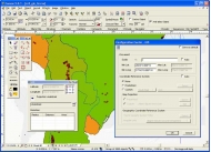
The CANVAS 9 Advanced GIS Mapping Edition adds native support for Geographic Information System (GIS) data to Canvas. You can take measurements in geographic coordinates, import industry standard SHAPE and GeoTIFF files into unlimited numbers of automatically aligned overlapping layers and choose among the following options:
2, 104 Coordinate Reference Systems
67 Operation Methods (like Mercator, Albers Conic Equal Area?)
1, 052 Map Projections
302 Geodetic Datums
21 Angular units
45 Length units
The CANVAS 9 Advanced GIS Mapping Edition bridges the gap between dedicated GIS analysis software and generic "DTP" software. For many applications CANVAS 9 GIS Mapping Edition can now replace programs costing thousands. For the rest, CANVAS 9 GIS Mapping Edition is now the preferred "last mile" publishing companion to dedicated GIS analysis software.Files Supported include:
oMapInfo, oARC/INFO, oUSGS, Digital Line Graphs, oTIGER(Census), oMrSID (Win. only), oGML (Geography Markup Language), oSDTS (USGS Spatial Data Transfer Standard), oGIS Text oGarmin (GPS), oECW (Enhanced Compressed Wavelet Images, oS57 (IHO International Hydrographic Organization)
|
More to download:
ODBC View
ODBCView is a free SQL query tool to view and export data from any OBDC database. Data is displayed on a read-only grid and can be exported to a CSV or HTML report. Note, any valid SQL statements can be executed including SQL UPDATE and DELETE stmts.
SplineCalc
SplineCalc is multipurpose scientific calculator for implementation of various mathematical operations with maps (grids), data tables, lines, polygons and numbers...
z/Scope Warp
z/Scope Warp is a GUI/HTML-enabled terminal emulator. Runs as a stand-alone and web-browser enabled for accessing AS/400 iSeries and IBM Mainframes under Microsoft Windows platforms. z/Scope Warp provides SSL 2,3 and TLS 1.0 encryption.
NetChess
NetChess is a chess program that allows
you to play with opponent over internet/intranet
or on the local computer. Features include chat, load/save game,chess-clock, move logging,
coordinate system.
AllTrans
AllTrans can be used for world wide professional coordinate transformations between international and national coordinate systems with or without geodetic datum change. Transformations between State-Plane-Coordinates (NAD83, NAD27, Transverse Mer...
MECHMOD 2.0
MECHMOD (c) is designed for an automation and isualization of kinematic calculations of plane lever mechanisms of arbitrary circuits. MECHMOD (c) is applicable for structural and kinematic analysis of plane lever mechanisms. It allows you to make...
TW Pro
TW Pro� is truly the Swiss Army knife of Windows Desktop Management Utilities. The program's main user interface consists of a pair of system tray icons that are always conveniently located on your desktop's task bar. The main tray icon is used f...
Canvas GIS Mapping Edition
CANVAS 9 GIS Mapping Edition includes direct support for Geographic Information System data. You can take measurements in geographic coordinates, import SHAPE & GeoTIFF files into unlimited numbers of automatically aligned overlapping layers.
Folder Marker - Changes Folder Icons
This utility lets you change folder icon (mark folders) by priority (high, normal, low), project completeness level (done, half-done, planned) and type of information stored in them (work, important, temp and private files).
|
|
|
Windows Backup |
Looking for backup software? Try Handy Backup - automatic data backup to DVD, CD, FTP, network, or Online. Client-server enterprise backup software.
|
|
Top Downloads |
SimplySMS: Send/Read SMS (via serial port) for GSM phones (Siemens,Nokia,others)
Convert 3GP files to MP4 and AVI, video with Free 3GP Video Converter
Simple and flexible Personal Accounting Software
|
|